OWNERSHIP: 100%
The Lapon
Gold Project
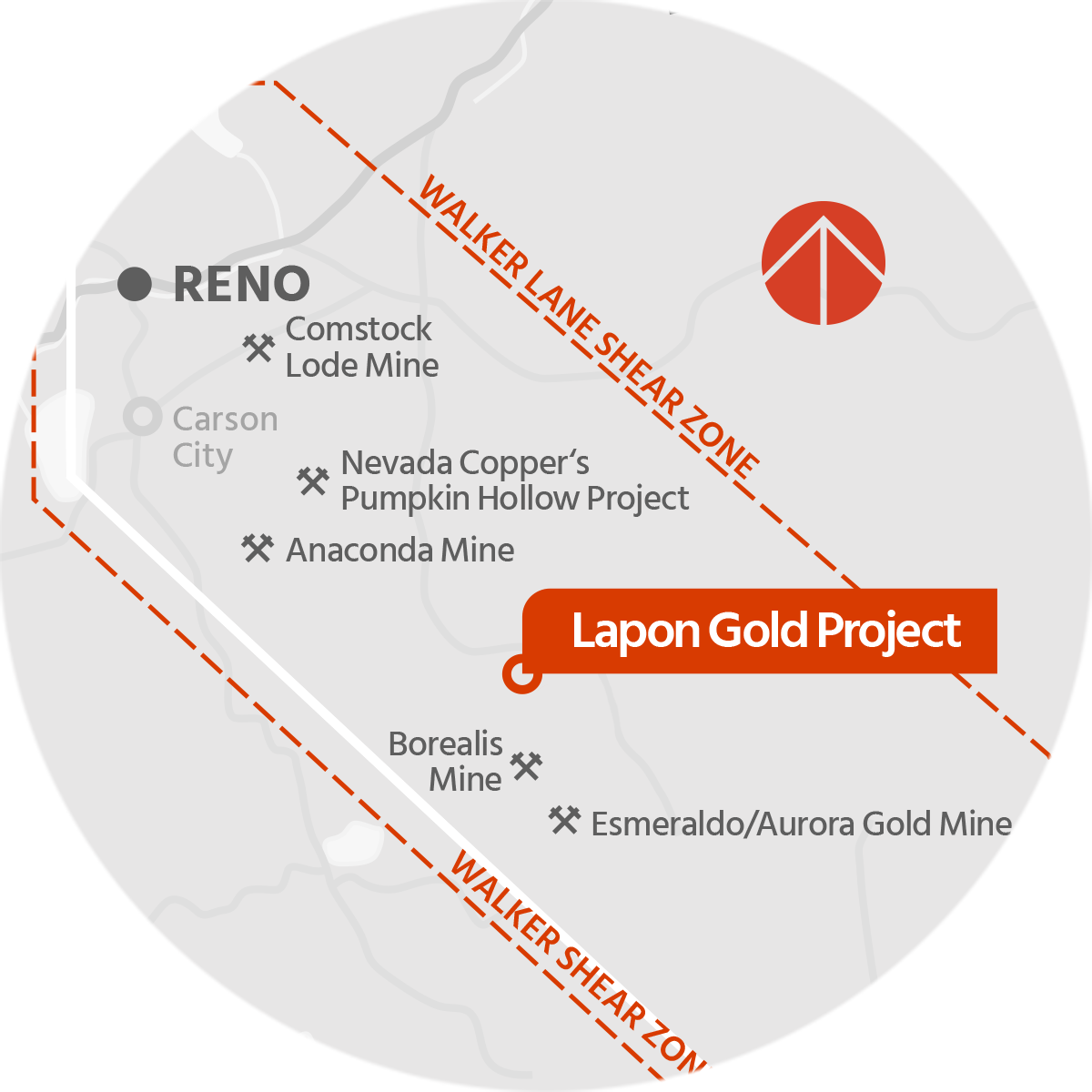
The Lapon Gold Project is located within the Walker Lane shear zone, a 40 -100 km wide structural corridor extending in a southeast direction from Reno, Nevada. Situated within this trend are numerous gold, silver, and copper mines, notably the historic Comstock Lode mines in Virginia City, the past-producing Esmeralda/Aurora gold mine, with reported production of some one million ounces and the Anaconda open-pit copper mine in Yerington, Nevada.
Fully Drill Permitted with Significant Exploration and Expansion Potential
The project consists of 149 claims (3101 acres), including Lapon Canyon, the Pikes Peaks claims 4 kilometres to the north, and the Rattlesnake Range Front claims 3 kilometres to the west and over 600 meters lower than the present drilling at Lapon Canyon. The properties are easily accessible by secondary state roads from the main highway, with a state grid power transmission line passing within three kilometres.
VIDEO GALLERY


Lapon Gold Project Areas
Lapon Gold Project Zones
Lapon Canyon
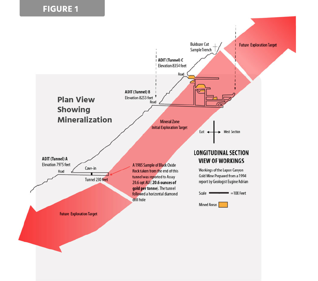
LAPON CANYON HISTORY
Small scale high grade mining began on the project in 1914. Approximately 600 meters of drifts and raises were developed from two adits and a two-stamp mill was built. Further underground work was carried out, returning numerous assay values in the range of one ounce per ton, with a sample at the end of an adit returning 20.6 ounces per ton. (National Instrument 43-101, Montgomery and Barr, 2004). Additional work on the Project in the following years, included the installation of a ball mill and milling facilities.
Placer gold was originally discovered at the mouth of the Lapon Canyon around 1904. Placer mining up the creek resulted in the discovery of gold in the mine area in 1907, mining was also occurring in the Lapon meadows approx. 2.5 km upstream.
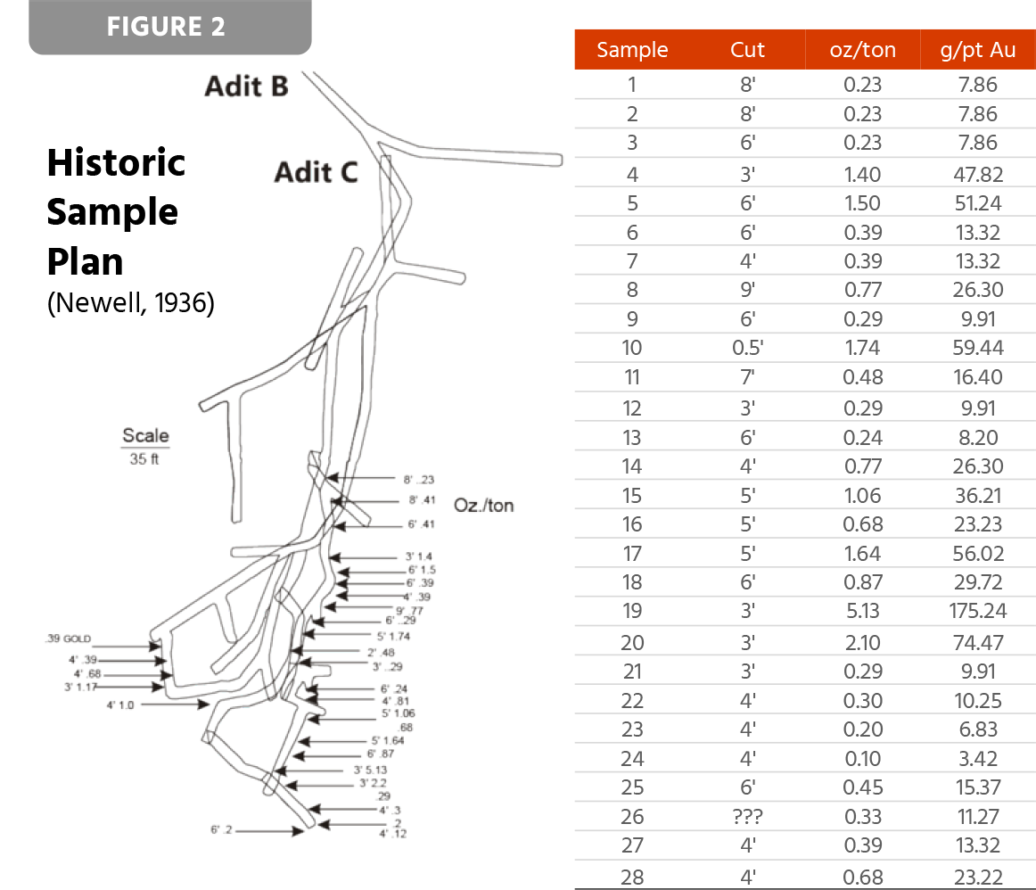
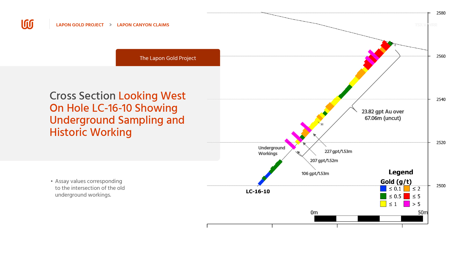
Small-scale high-grade underground gold mining occurred from 1914 onwards. The mine area at the top of the canyon was extremely difficult to access, indicating mineralization was rich enough to haul equipment and supplies up a steep canyon. Two adits were developed (B and C) with a sublevel and raise connecting them, approx. 600 metres (2000 feet) of underground adits and drifts were developed and a two-stamp mill was constructed. Cut-off grades in the stopes were reported to be 1 ounce gold per ton. In 1936 Newell sampled the adits and published values assaying as high as 5 ounces gold per ton (see figure 2).
In the early 1960s, Nylene drove an adit (A) 250 feet into the mountain and 275 ft below adit B. Nylene was targeting the down dip extension of the high-grade mineralization above. A sample taken at the end of this adit reportedly assayed 20.6 ounces gold per ton (National Instrument 43-101, Montgomery and Barr, 2004). Due to the large widths taken in adit (A) the stoped ore caused the adit to collapse. During this same time period, new mill construction was undertaken with the installation of a ball mill and tailings pond. A second larger ball mill (500 tons per day) was to be installed, but the larger ball mill still remains at the base of the canyon, uninstalled. However, It is reported that Nylene’s health and finances deteriorated before he could profit from the discovery and abandoned the project. The Nylene Adit potentially hit the down dip extension of the high-grade mineralization above, warranting the expansion of the mill (to 500 tpd). No further mining work was reported.
In 1990, Teck Resources Inc. discovered a surface area of argillitic alteration and low grade disseminated gold mineralization on the Lapon Canyon Claims, which they were able to trace over a strike length of 450 meters. Grid sampling over this zone returned an average grade of 2.01 grams per ton gold, in this zone which was named the Central Zone. Teck also completed trenching and a few shallow RC drill holes were drilled above the uppermost adit. In 2000, brief chip sampling program within adit B and C was carried out, without accessing the ore shoots (sublevel) along the walls. Values of up to 1.15 ounces per ton were returned.
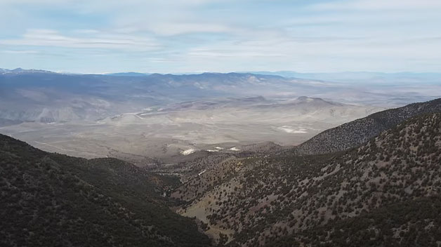
LAPON CANYON GEOGRAPHY
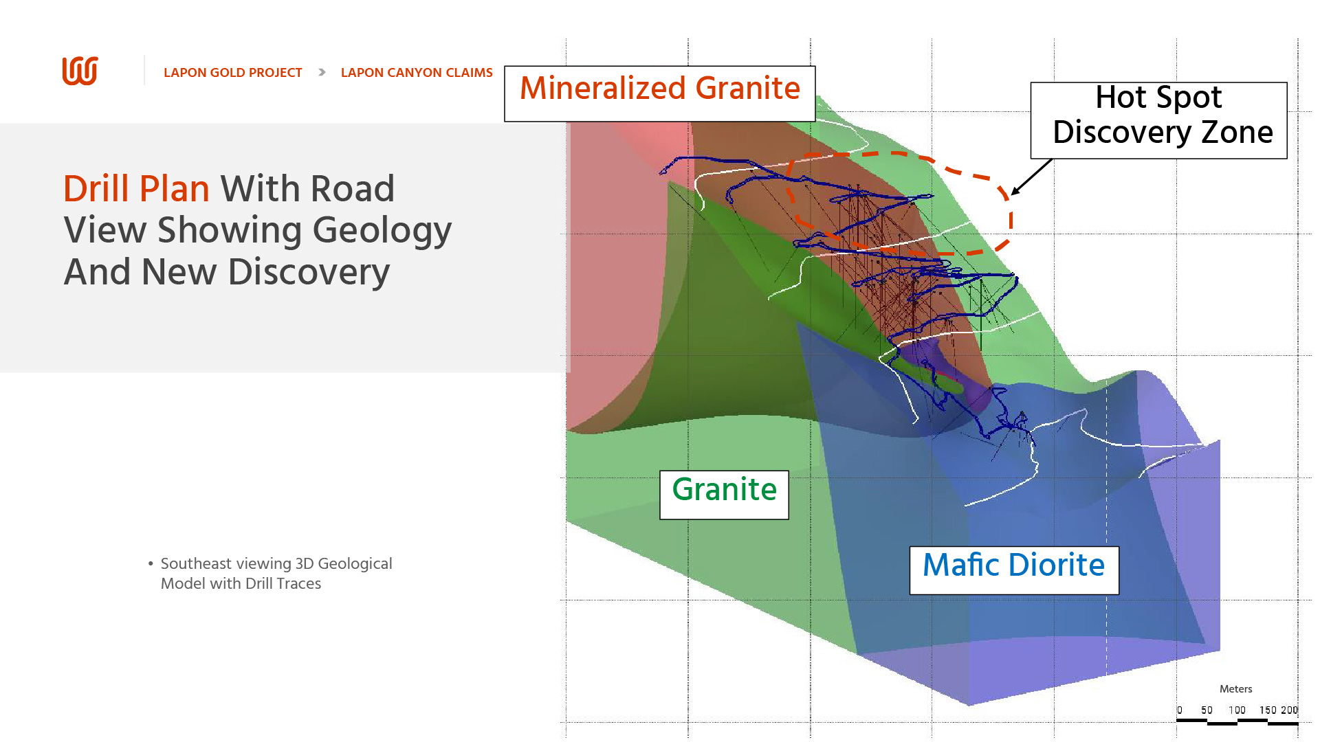
The Lapon Gold Project is cut by a series of steeply dipping cross fault structures cutting across the Walker trend, analogous to other cross fault structures responsible for many gold and base metal deposits in the world. These faults are heavily sheared and altered (sericite, iron oxides) with abundant silica, varying in width from 60 to 300 meters. Some of these structures have been encountered at Lapon Canyon.
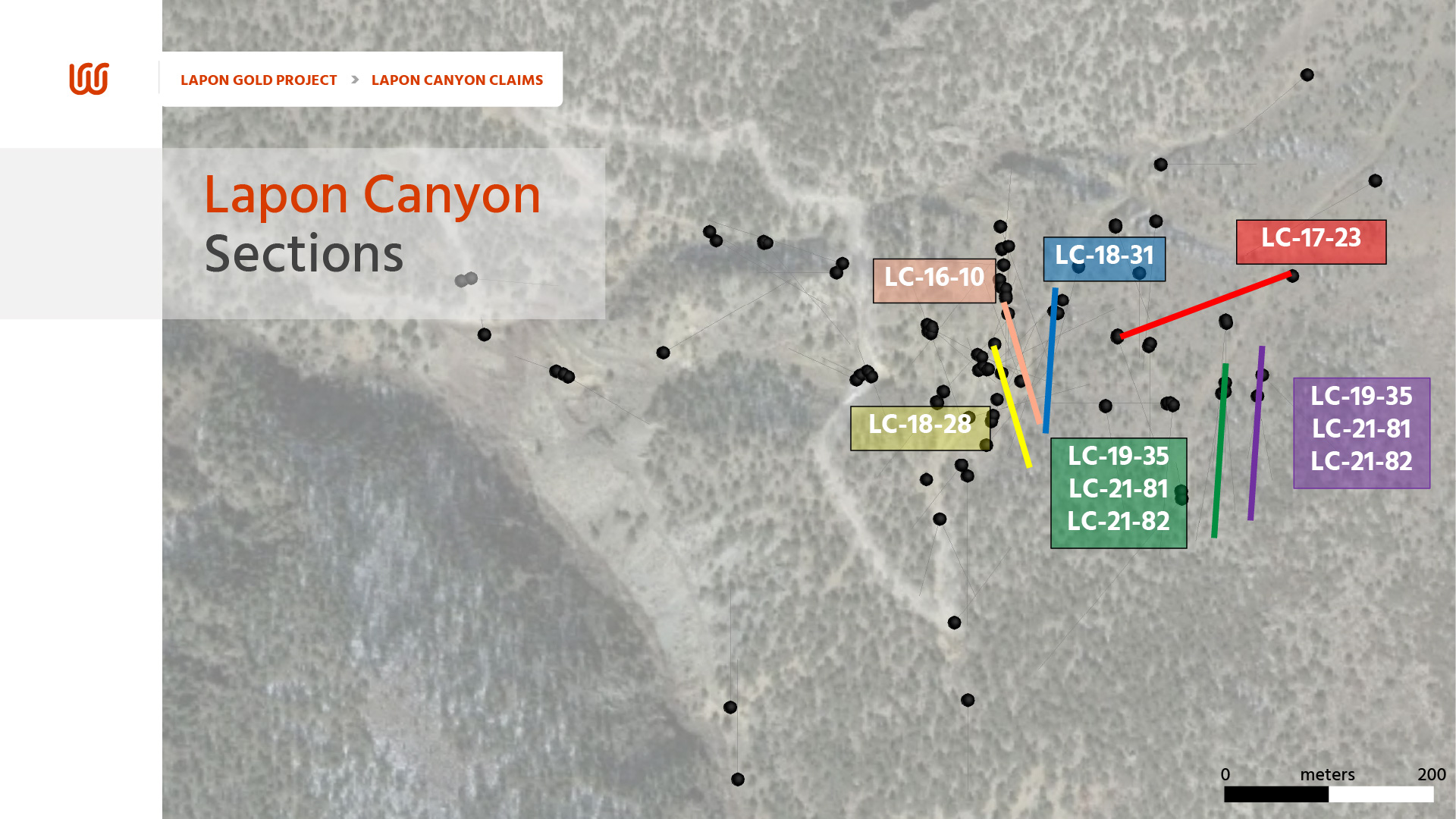
LAPON CANYON 2024 DRILL HOLE LOCATION MAP

LAPON CANYON DRILL HOLE TABLE
| Hole | Azimuth | Dip | Total Depth (ft) | Total Depth (m) |
|---|---|---|---|---|
| LC-15-01 | 273 | -55 | 360 | 110 |
| LC-15-02 | 75 | -45 | 420 | 128 |
| LC-15-03 | 130 | -60 | 395 | 120 |
| LC-15-04 | 270 | -45 | 260 | 79 |
| LC-15-05 | 60 | -45 | 490 | 149 |
| LC-15-06 | 290 | -50 | 160 | 49 |
| LC-16-07 | 120 | -50 | 365 | 111 |
| LC-16-08 | 350 | -45 | 60 | 18 |
| LC-16-09 | 160 | -45 | 490 | 149 |
| LC-16-10 | 165 | -47 | 300 | 91 |
| LC-16-11 | -90 | 400 | 122 | |
| LC-16-12 | 40 | -45 | 350 | 107 |
| LC-16-13 | -90 | 300 | 91 | |
| LC-16-14 | 118 | -50 | 400 | 122 |
| LC-16-15 | -90 | 260 | 79 | |
| LC-17-16 | 95 | -50 | 320 | 98 |
| LC-17-17 | 120 | -45 | 430 | 131 |
| LC-17-18 | 90 | -50 | 350 | 107 |
| LC-17-19 | 205 | -47 | 350 | 107 |
| LC-17-20 | 25 | -50 | 350 | 107 |
| LC-17-21 | -90 | 290 | 88 | |
| LC-18-22 | 350 | -45 | 100 | 30 |
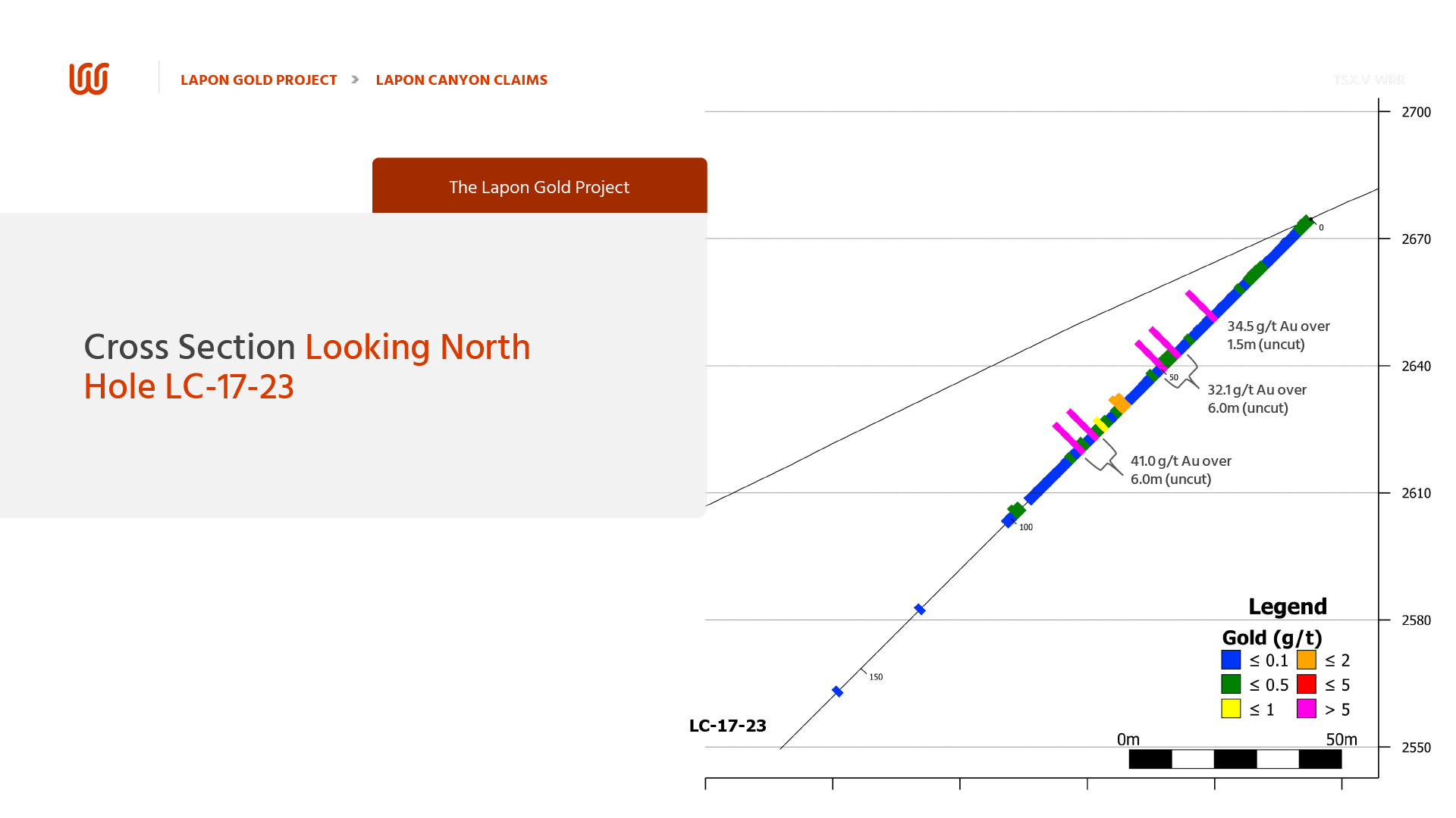
| LC-18-23 | 250 | -45 | 580 | 177 |
| LC-18-24 | 270 | -57 | 500 | 152 |
| LC-18-25 | -90 | 400 | 122 | |
| LC-18-26 | 288 | -48 | 500 | 152 |
| LC-18-27 | 120 | -60 | 360 | 110 |
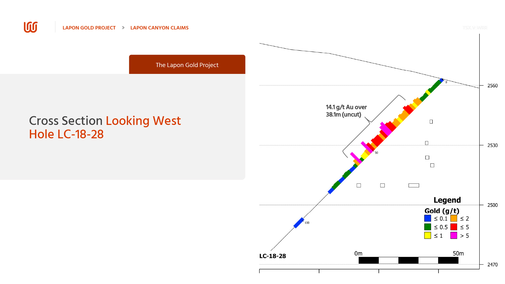
| LC-18-28 | 165 | -45 | 400 | 122 |
| LC-18-29 | 165 | -47 | 400 | 122 |
| LC-18-30 | 65 | -48 | 500 | 152 |
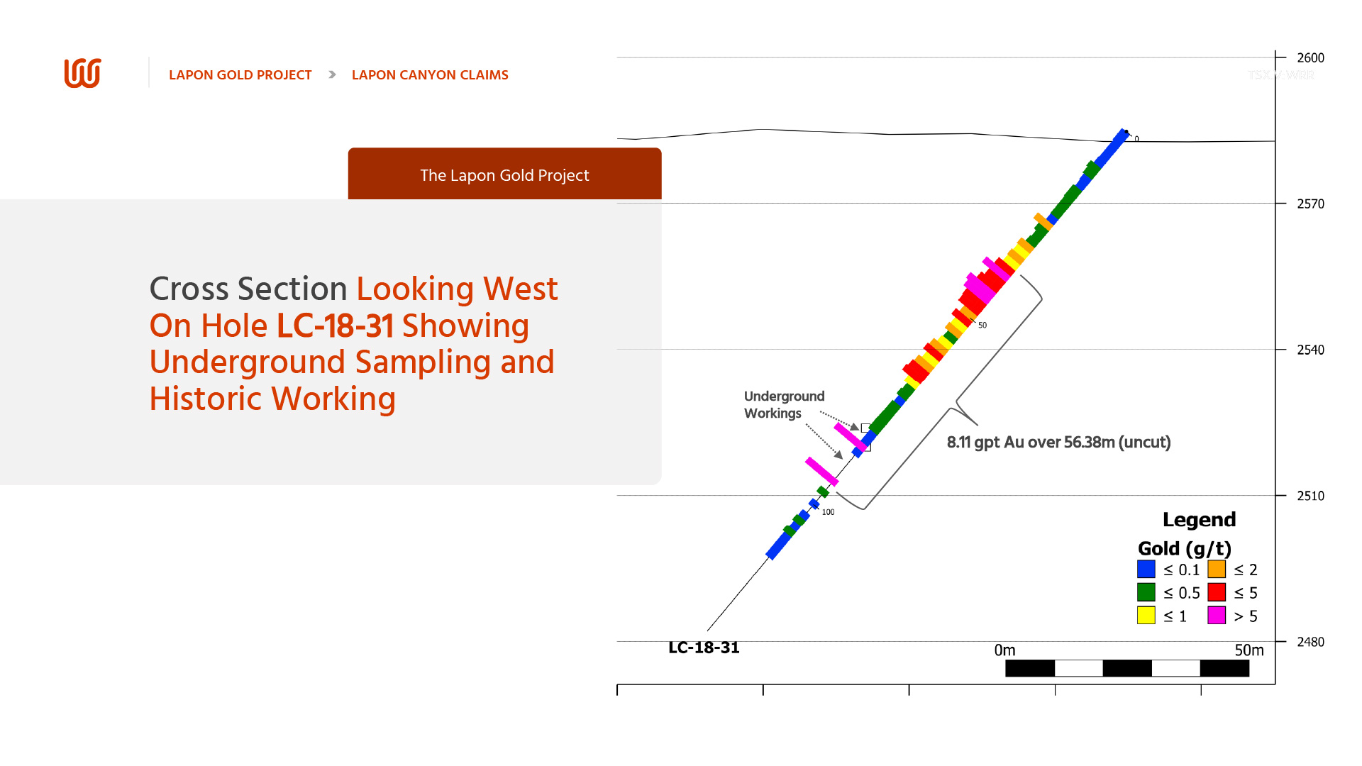
| LC-18-31 | 185 | -50 | 440 | 134 |
| LC-18-32 | 230 | -60 | 430 | 131 |
| LC-18-33 | -90 | 500 | 152 | |
| LC-19-34 | -90 | 400 | 122 | |
| LC-19-35 | 185 | -45 | 500 | 152 |
| LC-19-36 | 240 | -45 | 500 | 152 |
| LC-19-37 | 190 | -45 | 500 | 152 |
| LC-19-38 | 185 | -45 | 500 | 152 |
| LC-19-39 | 185 | -45 | 500 | 152 |
| LC-19-40 | 200 | -45 | 500 | 152 |
| LC-19-41 | 5 | -45 | 400 | 122 |
| LC-19-42 | 180 | -45 | 300 | 91 |
| LC-19-43 | 180 | -45 | 500 | 152 |
| LC-19-44 | 140 | -45 | 450 | 137 |
| LC-19-45 | 135 | -34 | 25 | 8 |
| LC-19-46 | -90 | 30 | 9 | |
| LP-20-1 | 37 | -45 | 315 | 96 |
| LP-20-2 | 219 | -46 | 325 | 99 |
| LP-20-3 | 42 | -44 | 330 | 101 |
| LP-20-4 | 218 | -55 | 330 | 101 |
| LP-20-5 | 47 | -44 | 330 | 101 |
| LP-20-6 | 45 | -45 | 330 | 101 |
| LP-20-7 | 218 | -45 | 490 | 149 |
| LP-20-8 | 220 | -48 | 780 | 238 |
| LC-21-56 | -90 | 400 | 122 | |
| LC-21-57 | 110 | -60 | 400 | 122 |
| LC-21-58 | 20 | -55 | 400 | 122 |
| LC-21-59 | 25 | -50 | 400 | 122 |
| LC-21-60 | -90 | 400 | 122 | |
| LC-21-61 | -90 | 350 | 107 | |
| LC-21-62 | 180 | -50 | 400 | 122 |
| LC-21-63 | 180 | -50 | 400 | 122 |
| LC-21-64 | -90 | 385 | 117 | |
| LC-21-65 | 180 | -60 | 400 | 122 |
| LC-21-66 | -90 | 400 | 122 | |
| LC-21-67 | 180 | -50 | 400 | 122 |
| LC-21-68 | -90 | 400 | 122 | |
| LC-21-69 | 160 | -50 | 400 | 122 |
| LC-21-70 | -90 | 400 | 122 | |
| LC-21-71 | 170 | -50 | 400 | 122 |
| LC-21-72 | 295 | -60 | 350 | 107 |
| LC-21-73 | -45 | 400 | 122 | |
| LC-21-74 | -45 | 400 | 122 | |
| LC-21-75 | -90 | 400 | 122 | |
| LC-21-76 | -90 | 400 | 122 | |
| LC-21-77 | -90 | 400 | 122 | |
| LC-21-78 | -90 | 400 | 122 | |
| LC-21-79 | 180 | -50 | 400 | 122 |
| LC-21-80 | -90 | 400 | 122 | |
| LC-21-81 | 175 | -70 | 400 | 122 |
| LC-21-82 | 175 | -45 | 400 | 122 |
| LC-21-83 | 180 | -60 | 400 | 122 |
| LC-21-84 | 195 | -50 | 460 | 140 |
| LC-21-85 | 155 | -60 | 400 | 122 |
| LC-21-86 | 195 | -60 | 370 | 113 |
| LC-22-87 | -90 | 400 | 122 | |
| LC-22-88 | 155 | -60 | 140 | 43 |
| LC-22-89 | 85 | -60 | 400 | 122 |
| LC-22-90 | 85 | -40 | 100 | 30 |
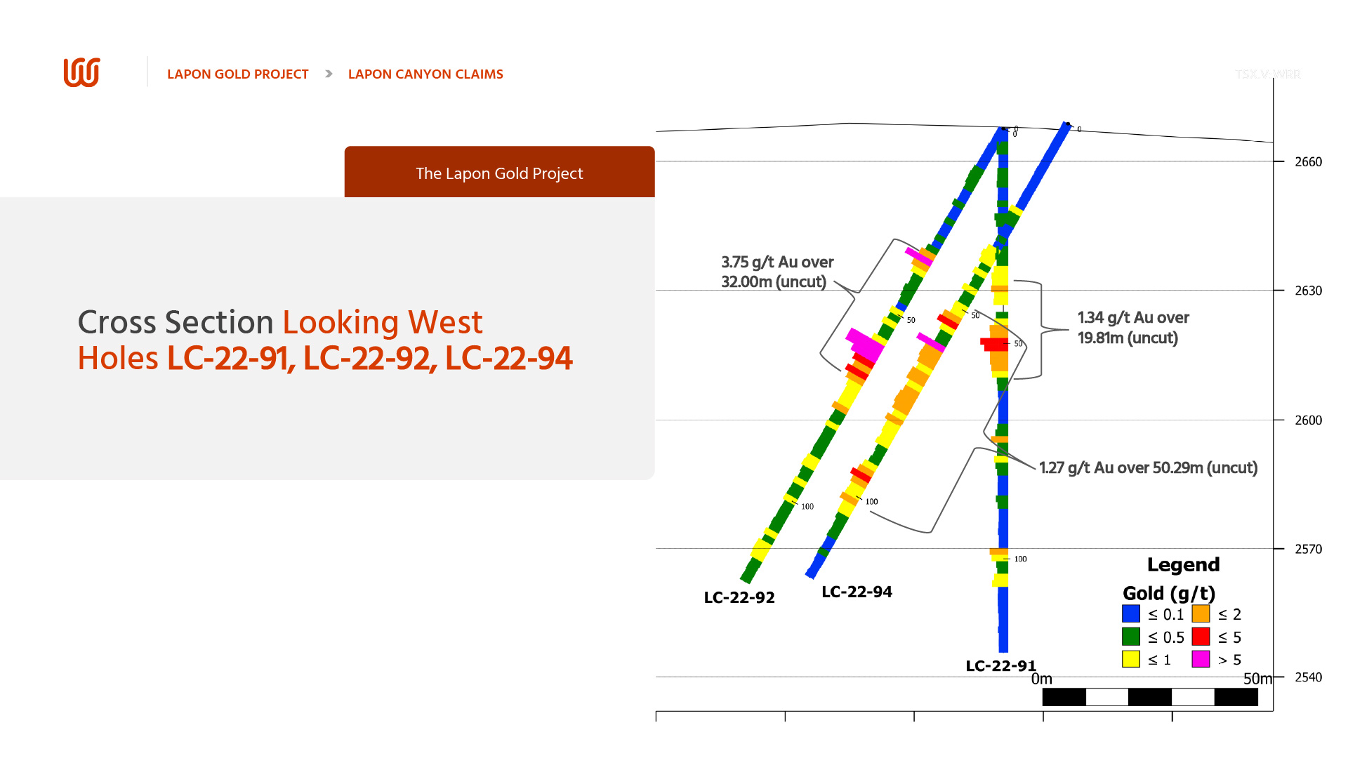
| LC-22-91 | -90 | 400 | 122 | |
| LC-22-92 | 170 | -60 | 400 | 122 |
| LC-22-93 | -90 | 400 | 122 | |
| LC-22-94 | 190 | -60 | 400 | 122 |
| LC-22-95 | 135 | -70 | 400 | 122 |
| LC-22-96 | 135 | -50 | 400 | 122 |
LAPON CANYON DRILL PROGRAM HIGHLIGHTS
| Drill Hole | From (m) | To (m) | Width*(m) | Assay (Au g/t) |
|---|---|---|---|---|
| LC 15-01 | 7.62 | 19.82 | 12.2 | 40.27 |
| Including | 18.29 | 19.81 | 1.52 | 292 |
| LC 15-02 | 30.48 | 32 | 1.53 | 66.8 |
| LC 15-03 | 7.62 | 25.91 | 18.29 | 6.88 |
| LC 16-10 | 0 | 22.86 | 21.34 | 32.47 |
| 54.86 | 67.06 | 12.19 | 67.97 | |
| LC 16-12 | 15.24 | 38.1 | 22.86 | 16.19 |
| LC 17-19 | 15.24 | 21.34 | 6.1 | 18.61 |
| LC-18-28 | 15.24 | 60.96 | 45.72 | 12.55 |
| Including | 57.91 | 59.44 | 1.52 | 221 |
| LC 18-29 | 12.19 | 18.29 | 6.1 | 69.86 |
| LC 19-42 | 65.53 | 70.1 | 4.57 | 220.92 |
| 77.72 | 79.25 | 1.52 | 199.07 | |
| LC 19-43 | 82.3 | 83.82 | 1.52 | 305.25 |
| 86.87 | 88.39 | 1.52 | 73.87 | |
| LC 19-45 | 1.52 | 3.05 | 1.52 | 346.4 |
NEW DISCOVERY HOT SPOT ZONE DRILL HIGHLIGHTS
| Drill Hole | From (m) | To (m) | Width*(m) | Au g/t |
|---|---|---|---|---|
| LC 18-23 | 32 | 33.53 | 1.52 | 34.5 |
| 44.2 | 50.29 | 6.1 | 32.07 | |
| 71.63 | 73.15 | 1.52 | 133 | |
| 76.2 | 77.72 | 1.52 | 30.7 | |
| LC 19-35 | 33.53 | 48.77 | 15.24 | 1.87 |
| LC 21-65 | 33.53 | 62.48 | 28.96 | 3.09 |
| Including | 33.53 | 38.1 | 4.47 | 7.77 |
| LC 21-80 | 10.7 | 59.5 | 48.8 | 7.62 |
| Including | 55 | 59.5 | 4.5 | 77.62 |
| And | 55 | 56.5 | 1.5 | 166.37 |
| And | 58 | 59.5 | 1.5 | 65 |
| LC 21-81 | 10.7 | 71.6 | 60.9 | 5.68 |
| Including | 41.2 | 59.5 | 18.3 | 17.76 |
| And | 47.3 | 48.8 | 1.5 | 99.78 |
| And | 53.4 | 54.9 | 1.5 | 39.98 |
| And | 57.9 | 59.4 | 1.5 | 50.98 |
| LC 21-82 | 0 | 122 | 122 | 1.84 |
| Including | 64 | 111.3 | 47.3 | 4.28 |
| And | 85.3 | 122 | 36.7 | 3.46 |
| And | 85.3 | 94.5 | 9.2 | 8.61 |
| LC 22-91 | 27.4 | 60.9 | 33.5 | 1.05 |
| LC 22-92 | 24.4 | 122 | 97.6 | 1.65 |
| Including | 57.9 | 60.9 | 3 | 26.95 |
| LC 22-93 | 39.6 | 64 | 24.4 | 1.25 |
| LC 22-94 | 32 | 105.2 | 73.2 | 1.05 |
* These are Assayed lengths
LAPON CANYON HIGHLIGHTED SECTIONS
2025 LAPON GOLD PROJECT DRILL PROGRAM
- The Lapon Canyon drill program will consist of systematic drilling on section for geological modelling purposes, exploration drilling to discover new gold mineralization and extend known gold mineralization.
- Follow up drilling for extending strike, width and depth at the Hotspot zone discovery.
- Drill program at Pikes Peak, following up on the initial 2022 drill program and 2024 underground channel sampling in an old Audit returned significant results, with certain samples assaying over 1 oz per ton, and other significant results. Drilling will focus on extension and delineation of the significant historical mine workings.
- The Rattlesnake Range Front follow up drill program will focus on the extensive historical mining activities, including several adits. Within the altered sheared zone encountered at Lapon Canyon, Rattlesnake is some 600 meters lower and 3 km on strike from Lapon Canyon.
Pikes Peak
PIKES PEAK OVERVIEW
Pikes Peak consists of an additional 36 claims located approximately 4 kilometres north of the Lapon Project. Company geologists discovered the Pikes Peak Property during the current detailed geological and mapping survey of the Company’s claim group and adjoining properties.
The Pikes Peak property contains numerous historical workings consisting of underground workings with vertical shafts, milling facilities and a network of existing roads providing access to all the historical workings. The Pikes Peak property hosts the potential to provide a northern extension to the Lapon Canyon project’s recently discovery range front zone.
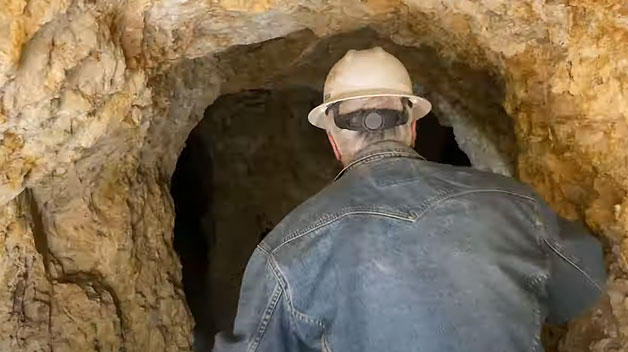
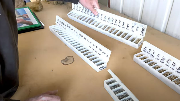
In 2024, Company personnel were able to re-open and access one of the old underground adits present on the property. Geologists completed underground mapping for the purposes of determining rock types, structure, dip and delineation of such. Underground channel sampling in the Adit wall returned significant results, with one sample assaying over 1 oz per ton, along with many other significant results.


PIKES PEAK HIGHLIGHTS
- 2019 Regional mapping and prospecting programs on the Pikes Peak claims returned significant results.
- Road access completed and fully drill permitted. Small successful initial drill program in 2022.
- 2024 underground mapping and channel sampling program returned significant results.
- Significant historical workings, consisting of milling facilities, adits, shafts (headframes), drifts, open cuts and prospect pits.
Range Front Rattlesnake
RANGE FRONT RATTLESNAKE OVERVIEW
The Rattlesnake Property comprises 15 unpatented lode claims on the adjoining ground south of the Lapon project’s recently discovery range front zone. These additional claims cover possible extensions of the range front zones to the south and add several additional drill target areas to the project.
The Rattlesnake property contains numerous historical workings consisting of several adits at different levels, underground workings with vertical shafts, and a network of existing roads providing access to connect all the historical workings.
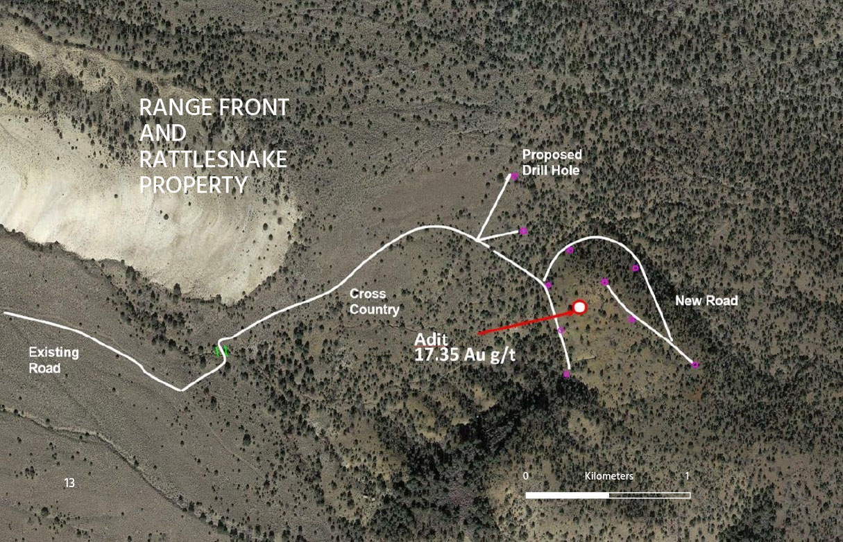
RANGE FRONT RATTLESNAKE PROPERTY
RANGE FRONT RATTLESNAKE HIGHLIGHTS
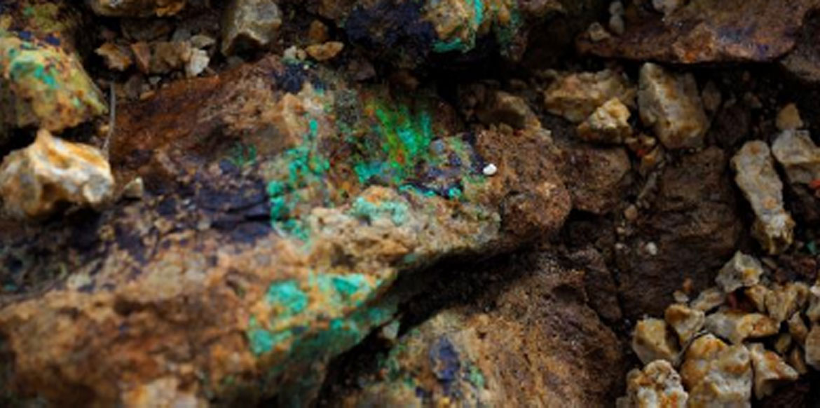
- Recent discovery of an intensely altered silicified zone with sulphide mineralization on the range front of the Lapon Project. The zone consists of sedimentary rocks and shows evidence of historical workings and one Adit.
- Recently Acquired Rattlesnake Property, 15 unpatented lode claims on adjoining ground south hosting possible extensions of the Lapon project’s recently discovery range front zone.
- Rattlesnake property contains numerous historical workings consisting of, several adits at different levels, underground workings with vertical shafts, and a network of existing roads providing access to connect all the historical workings.
- Initial Prospecting Results returned an impressive 17.35 Au g/t (chip sample from inside Adit) Zone is trending and open to the North and South.